Sunday, October 20, 2019

10/20/19 HOME FEELS SO GOOD

Our Deck View
WE ARE HOME AND IT FEELS SO GOOD

Driving from New Jersey to Rhode Island via the Tappen Zee Bridge only takes about 3.5 hours WHEN you travel on Sunday morning, otherwise it usually takes 5 or more.  Nothing beats New England in the fall and we are so glad to be home in time to enjoy the end of the fall colors.  

We are exhausted and need to leave more time to stop, relax and explore on the route home instead of letting "channel fever" take over.  We drove through 20 states and an estimated 8,000 miles over the past 7 weeks which is nuts.  Although the trip was FABULOUS, we are realizing that we don't like to be away from home that long AND we don't want to be driving this much in such a short period of time.  Oh wait, aren't we taking the RV to the Florida Keys for February and March 2020 and then on a 62 day trip to Alaska next summer, plus 4 weeks to visit friends and family on the way to and from Vancouver, Washington where the Alaska tour begins???????
Barn Island Sunrise Hike Near Westerly


Saturday, October 19, 2019

10/15 Minnesota to New Jersey

Park Ranger Took Our Photo
We stay at Baker Park Reserve Campground near Buffalo Minn to visit Aunt Joanne.  We have a lovely visit while John makes plans for next year's Hanley reunion at this park in June 2020.  We watch the news helplessly while Westerly gets slammed with what is called a "bombogenesis" aka a weather bomb.   Defined as a storm that undergoes extremely rapid drop in pressure, meaning it strengthens really fast.  Don't know the extent of the damage near our condo (neighbors say our unit is fine) but 88% of the town was without power at one point.  
Traffic Detour Through Illinois Corn Fields

Since leaving the mountains of Idaho, the 7 days of driving it took to get to Ohio has been relatively flat lands where from horizon to horizon day after day we mainly see corn fields and cows along with a bunch of pronghorn antelope and deer.  About the middle of Ohio we start to see trees from horizon to horizon instead of corn fields and then come the rolling hills.  Unfortunately there was a big traffic tie up in Illinois which our travel app routed us around.....oh by the way, they don't know we are an RV.  You would think by now we would remember to follow the tractor trailer trucks, instead we meander through corn fields on roads with signs saying NO TRUCKS!!! Away from the coasts this country is mainly rural, something very hard to imagine if you have grownup on the crowded coast lines.  So glad Zoe and Jack have driven across this country (by themselves no less) to have the experience of how it is all laid out.  A MUST FOR ALL....have to drive to taste, feel, see what our beautiful country is all about.

Mahlon Dickerson Reservation Campground, New Jersey

Have to be careful approaching New York on interstate 90 heading east because there are few RV campgrounds past Jefferson New Jersey and even fewer OPEN this time of year.  Thank goodness we know this and start planning early in the day for our final night so that we don't end up parking on the side of the road or being forced to drive through New York when we are bone tired at the end of the day.  The Mahlon Dickerson Reservation is a beautiful little campground that was open for a few more days and had room for us!  A lovely way to spend our last night but we are VERY ANXIOUS to be home.


Friday, October 11, 2019

10/11 Eastward Bound to South Dakota

Clearwater River
After the cruise, John joins me at Zoe's for an extra night giving an early Fall blizzard a chance to clear the Rockies.  We head East, pick up the truck and RV which was parked at the Clarkston Port in Idaho, and take  a spectacularly scenic US 12 along Idaho's Clearwater River where the sign says "Windy Road Next 99 Miles" and they weren't kidding.  There was rarely a straight stretch.  We stopped at Lolo Pass Ranger Station for hot chocolate and a great display of the area's history and geology.  
Lolo Pass - Border of Idaho and Montanta
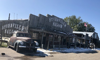
Taking another off the main highway route via US 212 through Montana and Wyoming brought more relaxed driving and more fabulous views.    Montana is BIG, we stay at Turah RV in Turah and Grandview RV in Hardin Montana.  Hard to imagine how simply people live out here when you get away from cities and populated coasts.  The sign on the saloon photo says "Cheap Beer - Lousy Food".  The word "urinal" was painted on the side of a building next to the saloon with an arrow pointed to the field.  Lots of pronghorn, sheep, cows and grass lands. 


Typical Off Road Western Stop
Along US 212 on Crow Reservation. MT
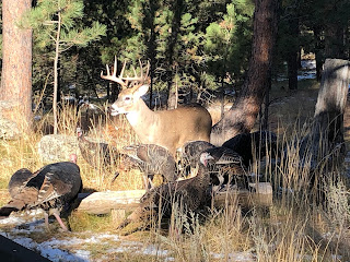
Spent a couple days with Joan and Craig on their 20 acres in the Black Hills of South Dakota hiking and rock hounding and feeding the dozens of turkeys and deer who come daily.  Got a flat on the RV on the way out of town, which after inspection resulted in 3 new tires on the RV bringing our total tire purchase this trip to 11: 4 on the truck, 4 on Zoe's car and 3 on the RV!Spent that night at Lake Vermillion Rec Area, a nice campground in SD. 


Feeding Deer and Turkeys
How exciting to get a photo of Jack and his new girl Michele at a friend's wedding in Hawaii.  After receiving the Navy's Fleet Scholar award which pays for Jack to go to graduate school, he is working his way through the application process, focusing on Fletcher School at Tufts in Boston.  Will be good to have him nearby!


Michele and Jack


Thursday, October 3, 2019

10/3-10 Snake and Columbia River Cruise


National Geographic Quest


We park the truck and RV at the Clarkston Pier on the Snake River in Washington and join 3 of Johns Dartmouth ’71 classmates and their spouses, for a week aboard the National Geographic Quest.  The premise of the trip is following the most Western part of the 1805 Lewis and Clark Expedition.   The Snake and Columbia Rivers flow through some fascinating geological  landscapes  which were carved over millennia by hundreds of historical floods and lava flows.
Jet Boat Through Rapids
Lava, Lava, Lava
First day we board jet boats and travel up the Snake to the Clearwater River through spectacular Hells Canyon.  Really fun speeding through all the white-water rapids.  Second day we journey to the entrance of the Palouse River and explore with the kayaks and zodiacs then bus up to Palouse Falls.  Day three was geology and history lectures and a hike up Crow Butte.
Palouse Falls

We go through 4 locks on the cruise dropping almost 800 feet along the way.  The boat is lovely and the crew and tour folks are top rate.  Lots of lectures on geology, history and naturalists.  

Until we reach Hood River on the 4th day, the trip has been beautifully remote. After walking the cool Mosier Tunnels (old highway road built 1921), I abandoned ship in Hood River and met up with Zoe who found a house to rent there.  We had a great couple days together and I was with her when she got the call saying she got the job as Northwest Coexistence Representative for Defenders of Wildlife!  
Mosier Tunnels

Dartmouth Crowd

History of Astoria Column
John continued on the cruise climbing Beacon Rock in Stevenson and exploring historical Astoria, near the Pacific Ocean where Lewis and Clark spent the winter. A GREAT TRIP!
Defenders of Wildlife NW Coexistence Rep


Friday, September 27, 2019

9/27 Camping with Zoe in Leavenworth, Washington


What an amazing camping trip with Zoe, Gabe, Pearl and Lulu at Eightmile Campground beside Icicle Creek in the Cascade Mountains surrounding Leavenworth.  The weather was unusually cold and damp for this time of year but the camper was
Making Sage Smudge Sticks
warm and dry and we had a grand time.  Didn't have a campfire to make our foil dinner and omelets in a baggie but it was fun and tasty just the same.


Hawaii friends, Jaynine and Dean invited us to join them as they have been camping here for several years to enjoy the annual Fall Leaf Festival in Bavarian themed Leavenworth.  They hold morning mediation for all at their campsite on the river. 

Bear Cubs Trying For Dinner
 The town nestled in the mountains is storybook lovely as was the parade.  Some local friends of theirs joined us for cocktails on a rainy afternoon so we had TEN in the RV; a record but it was still comfy.  Later, Zoe's friend Lindsay from WAZZU joined us for dinner. 
Our Mountain Pass Drive Out Of Leavenworth


Cousin Megan's mom is in the hospital in Salem, OR so we added an extra 400 miles to the trip to visit her.  She looked great and was so happy to see us!  Then off to Zoe's house in Walla Walla for a few days before our boat trip down the Columbia River.  Been ON THE ROAD for a month now and I knew I would be ready to go home after visiting Zoe :(  


Tuesday, September 24, 2019

9/24 Ford Dealership, Burley Idaho


John Getting Needed Stuff Out 
A "check engine" warning light is never a good thing, but especially when you are hauling an RV while climbing out of the desert between Salt Lake City and the Idaho border where there are few services for many miles.  Having just filled with diesel and DEF we figure it is an fuel exhaust system issue and proceed to a campground a few hours away near Burley, Idaho.  Next morning we hope the light is off but no luck so we drive not far to the Goode Ford Dealership at 8:30 a.m.  True to it's name (which has been operating here since 1919) they take us right in and yup needs some part for the exhaust sensor and oh by the way couple of other routine maintenance issues mind as well take care of while we wait for the part and also since we saw snow on the top of a mountain heading out of Utah yesterday, how about replacing the truck tires while you are at it.  Part arrives early afternoon but upon installing it a "little" piece breaks off due to corrosion (do you live near the ocean???) which brings everything to a halt and an order for a chunk of the exhaust system (of course can't just get the little $3.00 part that broke because Ford only sells it attached to the rest of the freakin exhaust system) which will not arrive until tomorrow afternoon.  After a couple of DEEP breaths, we ask if we need to get a hotel room or can we camp out in your parking lot..... no problem they say and we can give you a car and all the coffee and fresh baked cookies you can eat.  WHAT!  Boy, we are not on the east coast for sure where you would rarely get right in for service, would not be offered a car, would not be allowed to crawl in the truck on the lift and would not have had room in parking lot to park the RV never mind set it up for camping all night, etc. etc.   True western hospitality.
Our Living Room View 


 It was pretty quiet, having the place to ourselves and we both slept like a rock as the wind rocked us to sleep.   

9/25 Believe it or not the parts got lost in the mail, so these wonderful people ripped what we needed off a truck on their sales lot so that we could get underway.  AMAZING!!!

It is VERY rare that we drive at night but didn't get on the road until 4 p.m. heading NW on I-84.  We planned to stop before sunset but there are NO SERVICES for 75 miles once you hit the Oregon boarder through the mountains up down up down and around and around.  Glad we gassed up at the boarder and gas is much cheaper in Idaho.  We are on the Oregon  Trail.  Oh my, what those people endured.  

The first sight of civilization in Oregon is Baker City.  Backing into a site at night is a challenge because we are so tall and many RV sites have trees, etc.  The first place we called suggested we continue down the road a piece to another campground that had pull through sites... more Western hospitality!  Mt. View RV is a delightful spot.  I wish we had time to explore this historic town but we have 5 more hours of driving (more like 6 with stops) ahead of us to reach the campground in Washington and meet up with Zoe and our friends, the Nelsen's from Hawaii who are also camping there.

Sunday, September 22, 2019

9/22 The Narrows Trail, Zion National Park


Our last day in Utah ends with a spectacular hike on The Narrows Trail in Zion.  It's not spectacular because this canyon looks any different than all the dozens of canyons we have already seen on this trip.  It's spectacular because of it's unique experience and the
challenge it poses to your mind and body.  This is the best time of year for this hike as the water level is low (barring lots of recent rain) and the water temperature is a balmy high 50's.  Dress warm as the air temp was in the low 60's in the morning and no sun reached the river for the 2 hours it took us to go 1 mile up the river and back.


Whoa Whoa Whoa,  How High Does It Go


That being said, you are hiking on the rocky bottom of the rushing Virgin River at least 75% of the time.  Not a problem after the first 10 minutes because in our brand new hiking boots, you couldn't feel your feet anyway.  (TIP: rent insulated water sox and boots in town at any cost! Folks who did said their feet were warm.  WHAAAA)  Also bring both hiking poles as you will need them to maintain your footing on the rocks in the rushing water and like all other hikes, go early as the trails get more crowded as the day goes on. Oh yeah, forgot to tell you, you have to hike a mile before you even get to the river!  WHAT A BLAST!


Today's Hike: 4.5 miles (600 feet elevation changes)

Past 3 days in Zion: 15 miles (2,200 feet up, 2,200 feet down)

11 Days of Utah Hiking Totals:  45 miles (9,521 feet up and down, means we hiked up 4,760.5 feet and down 4,760.5 feet.  A mile is 5,280 feet!)  That's just on the trails, never mind all the other walking around we did in the parks.  

I learned something very important about myself this trip.  My body is still capable of a LOT MORE than my mind has given it credit for.  I had no idea that I could do this much hiking day after day while climbing over rocks, hiking massive changes in elevation, walking in cold water for hours on river stones.  It is true that a cortisone shot in my heel before we left and a bottle of ibuprofen and many ice packs were required, BUT WE DID IT!

Happy 70th Birthday John on October 24, 2019 and Happy 65th Birthday Debra on November 21, 2019. WE ARE BEASTS!  


Saturday, September 21, 2019

9/21 Kolob Canyon Wilderness, Zion National Park

Kolob Canyon
Zion was so crowded we decided to explore the much less traveled Kolob box canyons in the northwest corner of the park, about 45 minutes away.  Many place names in Utah and the parks we have recently visited were given by early Mormon settlers.  Kolob—in Mormon scripture, the nearest star to the planet where God resides. They also renamed the area Zion when they came in 1858 , which is ancient Hebrew for sanctuary or refuge.   The native culture called it Mukuntuweap, meaning straight canyon.  

We hiked the 5 mile Taylor Creek Trail which crosses the creek dozens of time, passes two old homestead cabins from the 1930's to Double Arch Alcove where we had lunch.  They warn against mountain lions here but besides squirrels and birds the only thing we saw out of the ordinary was this tarantula. A reminder that we are in the desert.  
Double Arch Alcove with Chef Boyardee

This may be the best trail of the trip for me.  This relatively flat unimproved trail through the wilderness looking up at spectacular 2,000 foot Navajo sandstone cliff walls was peaceful and absolutely breathtaking.

On the way back we stopped to buy some elk and buffalo jerky at an old Native American looking shop.  The shop owner told us that the wooden hut outside was a 173 year old Navajo women's hogan that had been passed down through the family women to the last Navajo women owner who gave it to him before she died.  It was the traditional home for the Navajo but when they moved to more modern housing, families kept a hogan "for spiritual ceremonies and to keep themselves balanced".  The door always faced east for the morning sun as well as good blessings.  How wonderful is that!
Navajo Women's Hogan


Today's Hike:  5 miles (900 feet elevation changes up and down)

Thursday, September 19, 2019

9/19 Zion National Park, Springdale, UT


We are too long and too tall to fit through the old 1 mile tunnel on Rt 12 coming into Zion from the east so we had to take the long way around  (Rt. 15) and go west through this cute little arch. 


Sunset from RV, River Behind The Trees
Zion Canyon Campground is right outside the park on the Virgin River which you can tube on.  $51 a night (about same for all campgrounds near the parks) and it is crowded but we have a great site with a view of the beautiful rocks from three sides.  

The park's parking lots are filling fast at 7:30 a.m. and you can't drive through the whole park anyway so consider taking the park's shuttle buses which pick you up in town.  Cute town with lots of little shops and restaurants.  Zion is the 4th busiest park in the nation and by 7:30 a.m. there were over 100 people in line at the park for the shuttles. By 8 a.m. they come every 5 minutes and almost no lines. 
Angels Landing Behind Deb
9 People Have Fallen Off
John Coming Down From The STEEP Peak

9/20 Today was about another challenging hike, this time to Angels Landing.  We both hiked 1,400 feet to Scouts Lookout along a 2.2 mile paved trail. Deb had enough but John grabbed onto the chains and went half way to the peak, another quarter mile almost straight up.  Too crowded with nervous people for him to go any further. 

Zion was formed primarily by the Virgin River which today is more the size of a stream.  It is much fuller with Spring runoff and impossible to image what it must have been like to have carved this canyon out of solid rock walls.   
Cold  River Better Than Ibuprofen
John Looking Over River Into Zion Canyon


Today's Hike:  5.4 miles (2,900 feet of elevation change up and down)

Monday, September 16, 2019

9/16 Bryce Canyon National Park, Utah


Top Of The Rim
OMG OMG Bryce Canyon is one of the most stunning landscapes on earth.  Tectonic movement cracked the earths crust in one direction forming fins (layers of free standing stone walls) like in Arches, and then again in the opposite direction cracking those fins into chimney’s (free standing stone columns) which over 35 
Base of Hoodoos
Eye Level Hoodoos


million years of weather and erosion produced these beautiful shapes called hoodoos.  The stronger rock layers are the bulging parts while weaker layers erode faster making recesses and holes called windows.  These hoodoos are in the Bryce Amphitheater which is 12 miles long, 3 miles wide and 800 feet deep and can be viewed from numerous lookouts and trails. 


 The colors are vibrant and some appear transparent when the sun hits them just right as shown in the Navajo Trail at sunrise below.  See the tiny people on the trail on the bottom left to get an idea of the size of this place.  

Sunrise At Navajo Trail
9/16 We hiked the very challenging 5.5 mile Peek A Boo Loop over rock scrambles, and 3140 feet of elevation changes.  Only 700 feet to the bottom but the trail does hundreds of up and down up and down up and down, etc. etc. etc……. 


9/17 John hiked the 3 mile Navajo and Queen’s Garden Trails
Down, Down, Down Navajo Trail
with 1200 feet of elevation changes.    500 feet of that change is in the first half mile where the Sunrise photo above shows the top part of the trail and the other photo shows the trails switching back and forth due to how steep they are.  John is that tiny green dot on the very bottom of the trail. 


Later we drove to the end of the park road and both strolled the 1 mile Bristle Cone Loop through a fire ravaged fir forest high atop a mesa offering expansive views of the park.

Camping at Bryce Canyon Pines about 6 miles from the park is quiet and in the trees.  Many other RV parks are closer but I expect they will be more crowded.  The parks are still very busy this time of year but comfortable.  There is no way I would do this in the summer.  There is vacancy in many of the hotels we have seen near these national parks but all of the RV parks in the parks have been full for months, and most of the closest RV parks are full as well so book EARLY. 

9/18 We take a much needed "no truck day" to clean house, do some RV maintenance, laundry, and rest our weary bones.  We even talked to both kids this morning!  We did some planning for our camping trip with Zoe next week and talked about their challenges finding a house to buy or rent in White Salmon area and Jack told us about his girl and his research on graduate schools.

Four parks are enough for one trip, our eyes are starting to glaze over and our bodies are pretty tired.  We are ready to move on.

Bryce Hikes:  9.5 miles (2,371 total elevation changes up and down)

Saturday, September 14, 2019

9/14 Capital Reef, Fruita, Utah


 About 1.5 hours west of Moab the landscape changes a bit.  We are driving at a lower elevation than Arches so we are seeing  layers of earth not exposed in Arches.     More of the red broken strata has  been exposed for more millennia than in Arches so it looks like red drip sandcastles like we used to make at the beach.  Billions of cubic feet of sand piles as far as the eye can see in all colors, from erosion at the base of massive exposed buttes. 
Antique Orchards and Capital Dome in Background

 The tiny town of Fruita was settled by Mormon pioneers escaping religious persecution in the 1880’s.  They subsisted by planting orchards which maintained about 10 Mormon families up to 1960.  You can eat as much as you can pick while in the orchards but have to pay $1 a pound for what you take away.  We picked 20 pounds of apples and peaches!  The park staff maintain these orchards using heritage techniques including the old time irrigation drains.  Much of the fruit are heirloom varieties dating back to the late 1800's.  

We dry camped about 15 miles from Fruita down route 12 off in Singletree Campground.  If we had known,  there are areas just west of the first visitor center( going west on 24) where campers  pulled off the road into natural unimproved areas and boondocked (camped for free).   There are lots of boondock areas out here.

A Reef Like Rock Structure
Okay, so how the heck did something in the middle of Utah's high plateau desert get names Capital Reef?  The "Capital" comes from the dozens of white rock domes in the landscape that look like the dome on our Capital building in Washington D.C.  Look again at the orchard picture above and you will see a "Capital" dome in the background.

Some say the reef was named by early explorers (white man did not explore here till mid 1800’s) because it was a natural barrier in the landscape, others say it was because there are areas that look reef like.  See Debra sitting at the bottom of such a "reef".

Waterpocket Fold in Capital Reef

The reef surrounds a unique long wrinkle in the earth known as the Waterpocket Fold. The elevation here is from 3,800 to 8,900 feet above sea level and this fold captures what little rain it gets.
  
Cohab Trail
We hiked the Cohab Canyon Trail which got it’s name from the legend that the Mormon's escaped into these parts when hiding out from the Fed’s raids trying to shut them down.  It is only 3.2 miles but the first third mile is 440 feet up.   

Hiking along the valley river wash was beautiful. Does something look out of place in this red and white rocky landscape?  How did those black lava rocks get there?  About 25 million years ago volcanic activity far west of here spewed lava rocks which were transported here by ancient river and sea flows. 

Today's Hike:  4.4 miles (880 feet elevation change up and down)